Mozart Cycle Path – Stage 20: Inzell – Kössen (Variant, Part 3)


© Euregio Radgruppe - SalzburgerLand, Chiemgau, Chiemsee-Alpenland, Berchtesgadener Land - ©Chiemagu Tourismus

Podaci o ruti
38,23km
586
- 831m
305hm
353hm
02:34h


- Kratak opis
-
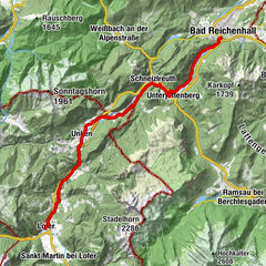
At this stage, we start from Inzell towards Reit im Winkl. We then cycle between the mountains to Ruhpolding. Past the Chiemgau Arena, which has since developed to become an Olympic base, we then arrive at the mountain lakes of Lödensee, Mittersee and Weitsee. We cycle on to Seegatterl and Reit im Winkl. Now it is not much further to Kössen, this stage’s destination.
- Teškoća
-
lagano
- Vrednovanje
-
- Wegverlauf
-
NiederachenVorderbichl0,7 kmHinterbichl0,9 kmKessel-Alm1,3 kmGschwendt1,5 kmRamsen1,6 kmOberhausen2,4 kmUntereben5,5 kmInfang5,9 kmGnaig6,1 kmHäusler6,4 kmWiddmoos7,0 kmHutzenau7,8 kmOrt8,4 kmWaich9,6 kmFritz am Sand10,2 kmFuchswiese12,3 kmBiathlonzentrum13,0 kmZirnbergalm13,3 kmSeehaus15,2 kmSeegatterl24,8 kmGasteig30,0 kmGroißenbach30,6 kmReit im Winkl (692 m)31,3 kmUnterbichl32,4 kmKaltenbach35,1 kmSternenhof36,3 kmHütte36,6 kmKössen38,0 kmHeiliger Petrus und Paulus38,1 km
- Beste Jahreszeit
-
sijveljožutrasvilipsrpkolrujlisstupro
- Höchster Punkt
- 831 m
- Zielpunkt
-
Kössen
- Höhenprofil
-
 © outdooractive.com

- Autor
-
Die Tour Mozart Cycle Path – Stage 20: Inzell – Kössen (Variant, Part 3) wird von outdooractive.com bereitgestellt.
GPS Downloads


Opće informacije
Einkehrmöglichkeit
Flora
Aussichtsreich
Weitere Touren in den Regionen