© Tourismusverband Südburgenland - Harald Popofsits

- Teškoća
-
lagano
- Vrednovanje
-
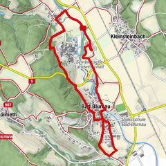
- Wegverlauf
-
Güssing (229 m)Buffet4,4 kmGüssing (229 m)5,0 km
- Beste Jahreszeit
-
sijveljožutrasvilipsrpkolrujlisstupro
- Höchster Punkt
- 230 m
- Zielpunkt
-
Parkplatz Kindergarten/Teichgasse
- Höhenprofil
-


- Autor
-
Die Tour Ramsar Güssinger Fischteiche wird von outdooractive.com bereitgestellt.
GPS Downloads


Opće informacije
Flora
Fauna
Aussichtsreich
Weitere Touren in den Regionen
-
Thermen- & Vulkanland
1324
-
Südburgenland
343
-
Güssing
90