
- Kratak opis
-
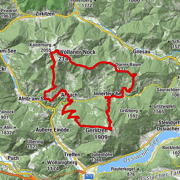
The Extreme Hiking Route leads hikers on existing hiking trails along the municipal boundaries around the central municipality of Arriach. There are 6 control points to pass along the route. The hiker has the possibility to choose between three variants.
Variant 1: "arriachXtreme" The ascent requires very good physical condition and stamina. All three stages must be completed within one day.
Variant 2: "arriachTrilogy" The tour takes place in three stages, but the time period can be chosen freely.
Option 3: "arriachEnussrunde" The extreme tour is divided into several days with overnight stays in the Geigerhütte am Wöllaner Nock and on the Gerlitzen.
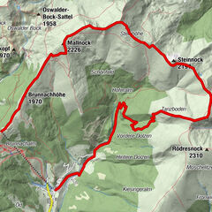
The hike along the municipal border of Arriach is extremely varied and includes the crossing of the two local mountains of Arriach, Wöllaner Nock (2145 m) and Gerlitzen (1911 m). Upon registration, the hiker receives a starter package consisting of a backpack, a lanyard with ticket, two drinks vouchers and a muesli bar. There is also a route description, route data and a hiking map.
After a successful hike, the participant receives a valuable SIGG drinking bottle and an entry in the success list on the homepage, depending on the variant chosen.
Registration fee for all three variants: € 20,-- (excluding overnight stays)
Of course the hiking route arriachXtreme can also be done at any time without registration (without starting package)!
- Teškoća
-
teška
- Vrednovanje
-
- Wegverlauf
-
Gasthof Alte Point0,0 kmArriach0,0 kmEvang. Vier-Evangelisten-Kirche0,1 kmSauboden0,3 kmMöderboden4,9 kmOberwöllan5,8 kmSt. Peter5,9 kmWöllaner Nock (2.145 m)13,7 kmWalderhütte (1.960 m)14,6 kmGeigerhütte16,4 kmBuchskopf (1.865 m)19,2 kmPrenteralm (1.745 m)21,1 kmDürrer Baum (1.771 m)22,8 kmJahnselriegel (1.403 m)27,8 kmBuschenschank Ölgishof29,2 kmEdelweiss Hütte33,5 kmInnerteuchen33,9 kmHuaba Hittn39,4 kmNeugarten39,6 kmGerlitzen (1.909 m)41,9 kmGerlitzen Gipfelhaus Restaurant41,9 kmStifterboden43,5 kmHinterbuchholz52,4 kmAuf der Tratten54,8 kmArriach55,5 kmGasthof Alte Point55,5 km
- Beste Jahreszeit
-
sijveljožutrasvilipsrpkolrujlisstupro
- Höchster Punkt
- 2.127 m
- Zielpunkt
-
Arriach Dorfplatz (Village Square)
- Höhenprofil
-


- Autor
-
Die Tour arriachXtreme wird von outdooractive.com bereitgestellt.