Zima
Ljeto
Vrijeme
Web kamere
Prenoćišta
Izleti
Suchverlauf
Suchvorschläge
Keine Ergebnisse gefunden
Suchen
Izleti
Home
Ljeto Österreich
Donja Austrija
Izleti
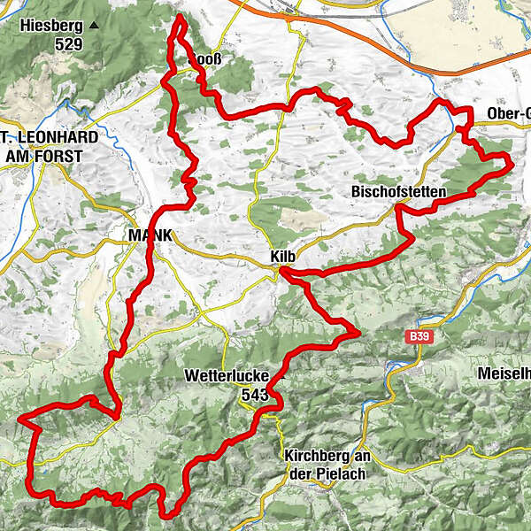
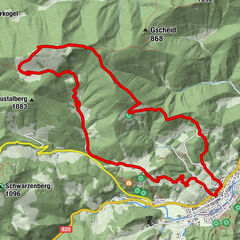
Rundwanderweg: Römerweg 651
Regije
Vrijeme
Web kamere
Izleti
Vrhunci
Kupališna jezera
Prenoćišta
Ponude
Pružatelj sportskih usluga
Događaji
Skijaška područja
Skijaško trčanje
Snowparks
Rundwanderweg: Römerweg 651
Merken
Karte
anzeigen
ausblenden
Drucken
Podaci o ruti
92,6
km
249 - 861
m
Distanz
2.256
hm
2.229
hm
Aufstieg
23:11
h
Dauer
gtwo
izrađeno am 17.05.2014
7.562
Aufrufe
Vrednovanje
Tehnika
Kondicija
Krajolik
Doživljaj
Höchster Punkt
861 m
3,6
Bewertung schreiben
Gesamtbewertung
5
57
%
4
0
%
3
0
%
2
29
%
1
14
%
Bewertungen
3,6
(7)
0 Kommentare
Bewertung schreiben
Error
Ein Fehler ist aufgetreten. Bitte versuche es erneut.
Vielen Dank für deine Bewertung
Bewertung wurde gelöscht
Tour melden
GPS Downloads
GPX
GPS Exchange Format (XML)
KML
Google Earth, Google Maps
QR Download Codes für Mobiltelefone
Rundwanderweg: Römerweg 651
QR Codes - Tourdownload für Mobiltelefone
GPX
KML
Weitere Touren in den Regionen
Mostviertel
2451
Pielachtal
1113
Kilb
195
Beliebte Touren in der Umgebung
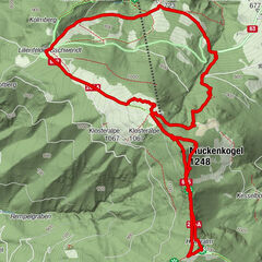
LILIENFELD Pichlersteig Hinteralm Muckenkogel Lilienfelder Hütte Ko...
srednje
9,1
km |
676
hm |
03:26
h
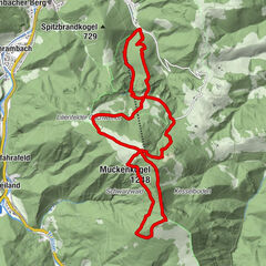
LILIENFELD Wasserfallsteig Muckenkogel Hinteralm Klosteralm Pichler...
srednje
13,5
km |
990
hm |
06:45
h
Eisenstein mit Start aus Türnitz
srednje
14,6
km |
787
hm |
05:00
h
TÜRNITZ Knedelhof Eisenstein Hochgraser retour 20191008
srednje
10,2
km |
620
hm |
04:15
h
Keine Einträge gefunden.
Die Suche ist aktuell nicht verfügbar.
Bitte Suche verfeinern.
Lokale Suchergebnisse
(<= 25km)
Više rezultata
(> 25km)
%count% Rezultati traženja
%name%
%type%
%elevation%
%population%
%lpButton%