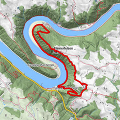
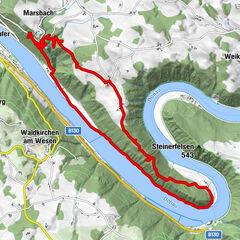
Bay. Habach über Endt, Unterühringsdorf und Pehring

Logo Bay. Habach über Endt, Unterühringsdorf und Pehring
Podaci o ruti
10,24km
443 - 499m
Distanz
61hm
62hm
Aufstieg
01:45h
 
Dauer
Vrednovanje
Tehnika
Kondicija
Krajolik
Doživljaj
Wegverlauf
Schildorf
0,2 km
Erlach
1,0 km
Itzling
1,5 km
Endt
2,8 km
Blick ins Landl
3,4 km
Schanze bei Habach
3,9 km
Penzing
5,2 km
Wiesing
6,2 km
Oberrühringsdorf
7,2 km
Pehring
8,2 km
Itzling
9,1 km
Schildorf
9,9 km
Höchster Punkt
499 m

Gesamtbewertung

5

0

%

4

0

%

3

0

%

2

0

%

1

0

%

Error
Ein Fehler ist aufgetreten. Bitte versuche es erneut.
Vielen Dank für deine Bewertung

Bewertung wurde gelöscht

GPS Downloads
  • GPX GPS Exchange Format (XML)
  • KML Google Earth, Google Maps
QR Download Codes für Mobiltelefone
Weitere Touren in den Regionen

Beliebte Touren in der Umgebung

Haibach: CICONIA-Loop Trail

srednje
11,2km | 338hm | 04:15h

Donauschlinge Schlögen

15,25km | 357hm | 04:00h