


The entire route runs through the Gran Bosco di Salbertrand Nature Park.Although it does not have too much of an altitude difference, it is considered demanding because the section of the path that passes...
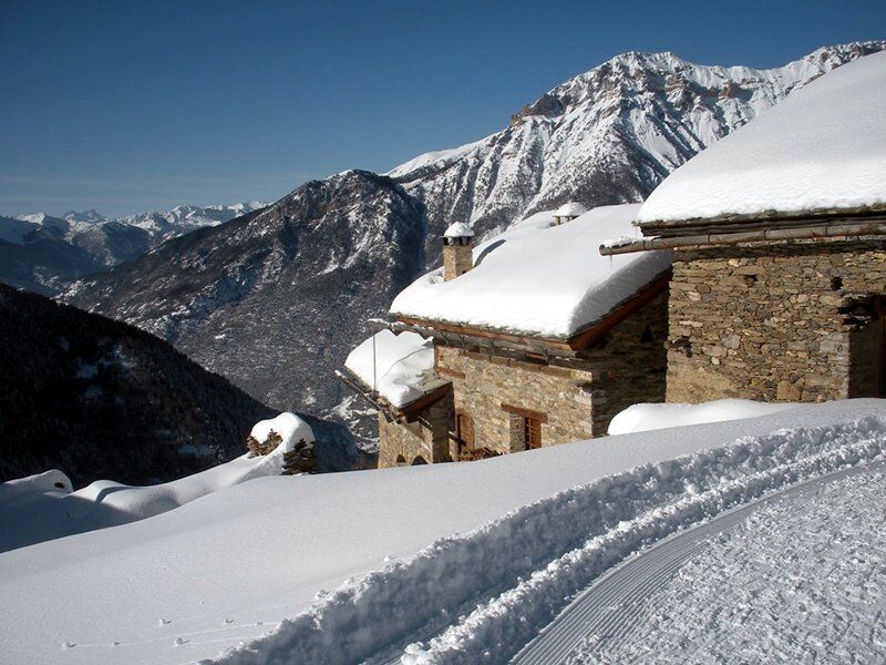
The entire route runs through the Gran Bosco di Salbertrand Nature Park.Although it does not have too much of an altitude difference, it is considered demanding because the section of the path that passes through the upper part of the forest is narrow and the walk can be uneasy at times.To access the Seu loop, it is necessary to walk the entire forest road from Monfol to Seu. In fact, the access point is located in the downhill part of the road that leads to the hamlet.When you reach the access point to the path (which you will find on your right on the outward journey), you can decide whether to tackle the most demanding part on the outward journey and then tackle the steep climb immediately or to continue downhill to the hamlet and then use the ‘high ring’ on the return journey.It is also possible to split the hike over two days and spend the night at the Arlaud Refuge. The experience of a night in a mountain hut in the heart of the Park is certainly one that you will not easily forget!
From the Tourist Office (Viale Genevris) at the roundabout go left towards Gran Villard. Park near Il Laghetto and continue on foot along the asphalted road or take the path on the right just behind the apartment buildings.
If you decide to use the path, once you reach Souberain, leave the house on the right and continue on the path to the left.
Cross the meadow with a viewpoint over Sauze d'Oulx and enter the forest. Here the path, for a short stretch, becomes a little less easy due to surfacing roots. On reaching the intersection with path no. 3 of the Natural Park, turn left downhill until reaching the hamlet of Monfol.
Turn right amidst the houses and read the plaque on the first house on the left "Baita Severina", which reports the legend on the origin of the name Monfol.
Once out of the houses, descend slightly to the left to finally take the Gran Bosco road (on the right) which leads to Ser Blanc.
After passing the bar that marks the entrance to the Nature Park, continue to the right on a first flat piece of road. At the crossroads, after about 600m, take the path on the left that leads to the Randuin mountain pasture. Past the alpine pasture, continue along the path until you reach the forest road that leads to Borgata Seu.
Turn left and follow the road to the beginning of the descent. Here, take the path to the left (signposted SNA). At the end of the ascent, the path tends to the left and continues for a short stretch halfway up the hill and then descends until it reaches the dirt track that leads from Seu to the Le Selle mountain pasture.
Clothing and footwear suitable for the winter mountain environment: snowshoes or crampons (in the case of compact or frozen ground) - poles - ARVA, shovel and probe.
Before starting out on any excursion, it is advisable to :
- consult the weather and avalanche bulletins issued by ARPA Piemonte, to inquire at the local Tourist Offices, Ski Schools or Alpine Guides.
- in the event of marked avalanche danger, it is inadvisable to undertake any excursion.
- the paths indicated are only beaten by people on foot: no mechanical, daily or periodic maintenance and beating service is provided.
- hiking in snowy environments requires the use of electronic signalling and search systems as provided for by Legislative Decree no. 40/2021 art. 26
By car from Turin: the exit from A32 Frejus- Turin motorway is at Oulx Circonvallazione. Follow the SP 214 and the signs to Sauze d’Oulx upon leaving the motorway.
By car from France: From the UK take the A 43 through the Frejus Tunnel (toll) then A32 motorway as far as Oulx.
By airplane: Turin airport is just over one hour away and is connected to Sauze d’Oulx and Oulx by private transfer or by public transport - bus to the main railway station in Turin, Porta Nuova; train to Oulx (railway line Torino/Bardonecchia); bus to Sauze d’Oulx. Train times and fares can be viewed and booked at trenitalia.com. The bus company web site is www.torino.arriva.it
By train: the mainline railway which connects Paris to Milan by TGV has a station in Oulx. Public transport and taxis services operate from Oulx station to Sauze d’Oulx. See also: www.snowcarbon.co.uk.
In the Monfol hamlet, the starting point of the excursion, there is no parking. We therefore recommend leaving your car at Gran Villar Laghetto or p.le Gran Comba or p.le Genvevris near the Tourist Office at the entry to Sauze d'Oulx.
Do not throw rubbish into the environment but take it away, picking up any rubbish left by others.
The walking times given are approximate and may vary depending on weather conditions and your own ability.
In the case of particularly compacted or frozen snow, the use of crampons is recommended.
Carry a rucksack with water and food.
In Seu, it is possible to eat and possibly spend the night at the Danilele Arlaud refuge.
We recommend that you call to check if it is open and to make a reservation.
Popular tours in the neighbourhood
-
5,0
BARDONECCHIA Colle Sommeiller
mediumMountainbike 25,4 km -
5,0
BARDONECCHIA Decauville
lightPješačenje 7,29 km -
5,0
CESANA T.SE To Fenils (No. 48)
lightPješačenje 4,29 km -
5,0
BARDONECCHIA Forte Jafferau Ring
heavyMountainbike 36,8 km -
SESTRIERE Assietta Road
mediumMountainbike 43,3 km -
La Via dei Saraceni (Sauze d'Oulx)
mediumMountainbike 33,6 km -
BARDONECCHIA Punta Colomion - Puys - Beaulard Ring
mediumMountainbike 24,7 km -
BARDONECCHIA Decauville - Rifugio Scarfiotti Ring
lightMountainbike 34,0 km -
CESANA T.SE Thures - Cima Bosco
mediumPješačenje 10,6 km -
Sentiero Italia: Salbertrand - Bardonecchia
mediumPješačenje 19,5 km
bergfex Tours


Ne propustite ponude i inspiraciju za vaš sljedeći odmor
Your e-mail address has been added to the mailing list.