© LEIPZIG REGION - Robin Kunz

© LTM GmbH - Andreas Schmidt

© LEIPZIG REGION - S. Beyer

© Stadt Schkeuditz - Verena Daser


- Kratak opis
-
The Elsterradweg leads for the most part along the banks of the Elster through a varied landscape. Numerous interesting sights and attractions along the way offer many opportunities for short and long stops.
- Teškoća
-
srednje
- Vrednovanje
-
- Wegverlauf
-
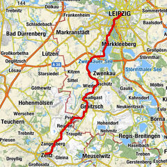
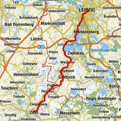
Landgasthof "Zur Eiche"0,1 kmProfen (139 m)0,1 kmBeersdorf0,5 kmLützkewitz0,9 kmAltengroitzsch4,8 kmGroitzsch (152 m)6,0 kmGriechisches Restaurant "Syrtaki"8,3 kmPegau (127 m)8,3 kmSt.-Laurentius-Kirche8,5 kmZauschwitz10,1 kmWeideroda10,3 kmWiederau12,9 kmKleindalzig16,2 kmZitzschen (126 m)18,0 kmHartmannsdorf-Knautnaundorf22,4 kmGasthaus an der Lauer29,6 kmDie Warze (112 m)35,1 kmLeipzig (118 m)35,1 kmSchkeuditz48,6 kmRübsen53,0 km
- Beste Jahreszeit
-
sijveljožutrasvilipsrpkolrujlisstupro
- Höchster Punkt
- 136 m
- Zielpunkt
-
Schkeuditz
- Höhenprofil
-
 © outdooractive.com


-

-
AutorDie Tour Elster cycling path between Pegau and Schkeuditz wird von outdooractive.com bereitgestellt.
GPS Downloads


Weitere Touren in den Regionen