"alpannonia" - feeder: Wenigzell - St. Jakob im Walde - Hochwechsel


© Oststeiermark Tourismus - Birgit Kandlbauer

© Oststeiermark Tourismus - Birgit Kandlbauer

© Oststeiermark Tourismus - Tourismusverband Oststeiermark

© Oststeiermark Tourismus - TV Jofglland-Waldheimat

- Kratak opis
-
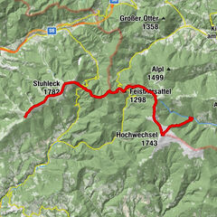
From the UNESCO World Heritage site of Semmering or the high-altitude health resort of Fischbach to the edge of the Pannonian plain near Köszeg, a path full of variety and attractions of nature leads: alpannonia®.
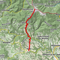
Or you can start the alpannonia trail in the fairytale village of Wenigzell. From there, the "power trail" continues to the neighboring community of St. Jakob im Walde. Across the hilly landscape, the trail then continues to the Hochwechsel. From there you can then join the main alpannonia trail.
- Teškoća
-
teška
- Vrednovanje
-
- Wegverlauf
-
WenigzellGasthaus Kristoferitsch0,0 kmGH Lueger5,9 kmSt. Jakob im Walde6,2 kmPfarrkirche Hl. Jakobus der Ältere6,3 kmKaltenegg7,5 kmBühlhofer Höhe11,4 kmBlasenkogel (1.313 m)12,8 kmBärengrube13,4 kmRabl-Kreuz-Hütte18,1 kmKaltwiesen Hütte20,2 kmHochwechsel (1.743 m)24,3 kmWetterkoglerhaus24,3 km
- Beste Jahreszeit
-
sijveljožutrasvilipsrpkolrujlisstupro
- Höchster Punkt
- 1.733 m
- Zielpunkt
-
Wetterkoglerhaus on the Hochwechsel
- Höhenprofil
-


- Autor
-
Die Tour "alpannonia" - feeder: Wenigzell - St. Jakob im Walde - Hochwechsel wird von outdooractive.com bereitgestellt.
GPS Downloads


Opće informacije
Einkehrmöglichkeit
Aussichtsreich
Weitere Touren in den Regionen
-
Hochsteiermark
4082
-
Joglland - Waldheimat
1513
-
St. Jakob im Walde
340