Stage 30 From Glacier to Wine North Route Fürstenfeld - Unterlamm


- Kratak opis
-
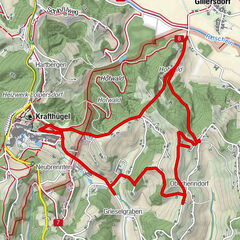
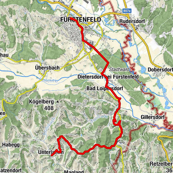
The hiking tour in the heart of the Thermen- & Vulkanland Styria leads us from the historic town of Fürstenfeld to Unterlamm, a beautiful small town, which lies in the middle of the hilly landscape of the Vulkanland. There should definitely be time for a visit to the town of Fürstenfeld with the imposing remains of its historic fortress wall, because the eventful history has also left us particularly valuable contemporary witnesses such as the Pfeilburg Museum. Leaving the city, the tour continues through the adjacent city forest and via the villages of Dietersdorf and Bad Loipersdorf uphill to the thermal spa of the same name, which is probably the most versatile thermal spa resort in Europe. The second section of the tour takes us along the network of trails of the Vulkanland through the lovely hilly landscape of this enchanting part of southeastern Austria. By the way, on the bird trail we can test our knowledge about the local forest bird breeding. Those seeking peace and quiet will find it at the end of the tour in Unterlamm at power spots such as the natural pond or the Lourdes Marian Grotto.
- Teškoća
-
lagano
- Vrednovanje
-
- Wegverlauf
-
Grazer Vorstadt0,0 kmInnere Stadt0,4 kmFürstenfeld0,5 kmHeilandskirche1,1 kmDietersdorf bei Fürstenfeld4,1 kmKleine Landküche5,0 kmBad Loipersdorf5,4 kmHartbergen9,4 kmHartbergen9,8 kmLauten10,2 kmSieglhof12,3 kmGeisterkapelle12,7 kmThier Kapelle13,5 kmLourdesgrotte16,7 kmUnterlamm16,8 kmGasthaus Riegler16,9 km
- Beste Jahreszeit
-
sijveljožutrasvilipsrpkolrujlisstupro
- Höchster Punkt
- 374 m
- Zielpunkt
-
Unterlamm
- Höhenprofil
-


-

-
AutorDie Tour Stage 30 From Glacier to Wine North Route Fürstenfeld - Unterlamm wird von outdooractive.com bereitgestellt.


Opće informacije
-
Thermen- & Vulkanland
1324
-
Loipersdorf bei Fürstenfeld
463
-
Loipersdorf
113