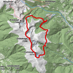
Podaci o ruti
13,51km
1.613
- 2.389m
869hm
860hm
04:06h

- Kratak opis
-
Wanderung über Lindersee zum Gipfel des Zirbitzkogels zurück über Lavantsee
- Teškoća
-
srednje
- Vrednovanje
-
- Wegverlauf
-
Alpengasthof Sabathy0,1 kmZirbitzkogel (2.396 m)4,5 kmZirbitzkogel Schutzhaus4,7 kmKöhlerhütte7,7 kmAlpengasthof Sabathy13,5 km
- Beste Jahreszeit
-
sijveljožutrasvilipsrpkolrujlisstupro
- Höchster Punkt
- 2.389 m


GPS Downloads


Weitere Touren in den Regionen
-
Erlebnisregion Murtal
1781
-
Steirisches Zirbenland
711
-
Mühlen
222