© Thüringen-entdecken.de - Paul Hentschel
- Kratak opis
-
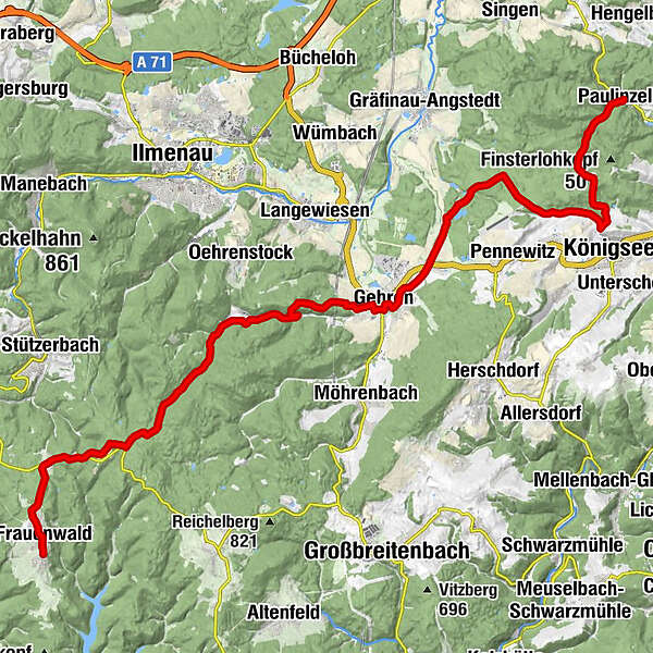
This section of the Luther Trail takes you through thick forests to the peaks of the Thuringian Forest following a route that the Reformer is said to have chosen for his journey to Rome.
- Teškoća
-
srednje
- Vrednovanje
-
- Wegverlauf
-
Paulinzella0,1 kmSeilersgrund1,9 kmMoosleite3,5 kmVogelherd3,9 kmHinter dem Mühlberge4,6 kmRehwinkel6,5 kmSchäfersrand7,0 kmAltes Ackertor7,7 kmLange Linie8,0 kmGottsholz8,4 kmWeißer Stein9,5 kmZur Jägersruh9,9 kmAm Galgenteich11,3 kmLuther-Kirche Jesuborn11,9 kmJesuborn12,3 kmViehtreibe12,6 kmGehren14,6 kmZur Parkschänke14,6 kmCarl-Marien-Höhe16,2 kmWaldbaude Großer Dreiherrenstein26,3 kmGroßer Dreiherrenstein26,3 kmKleiner Dreiherrnstein (825 m)26,7 kmAllzunah29,1 kmSkihütte Allzunah29,6 kmFrauenwald31,7 kmFrauenwalder Bauernstube32,2 kmSankt Nicolai32,2 kmGasthof "Drei Kronen"32,2 km
- Beste Jahreszeit
-
sijveljožutrasvilipsrpkolrujlisstupro
- Höchster Punkt
- 830 m
- Zielpunkt
-
Frauenwald
- Höhenprofil
-
 © outdooractive.com
-

-
AutorDie Tour Luther Trail: Section 10 – From Paulinzella to Frauenwald wird von outdooractive.com bereitgestellt.
GPS Downloads


Opće informacije
Einkehrmöglichkeit
Kulturell/Historisch
Aussichtsreich
Weitere Touren in den Regionen
-
Thüringer Wald
997
-
Coburg Rennsteig / Thüringen
500
-
Ilmenau
219