Damüls-Faschina | Rund um's Glatthorn

Logo Damüls-Faschina | Rund um's Glatthorn
Podaci o ruti
12,25km
1.121 - 1.703m
Distanz
335hm
606hm
Aufstieg
04:45h
 
Dauer
Kratak opis

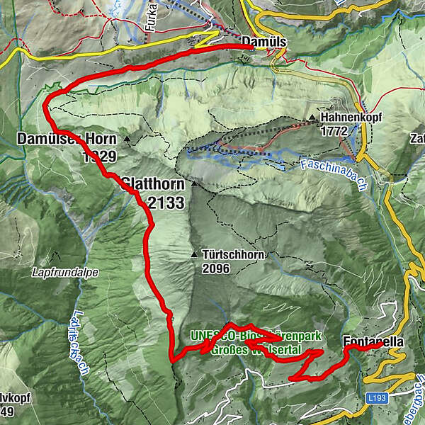
Damüls - Alpe Unterdamüls - Hintertürtschalpe - Türtschalpe - Mittelberg -Fontanella

Teškoća
srednje
Vrednovanje
Tehnika
Kondicija
Krajolik
Doživljaj
Wegverlauf
Damüls (1.423 m)
Alpe Unterdamüls
2,7 km
Türtschalpe (1.641 m)
6,2 km
Mittelberg
10,6 km
Pfarrkirche Hl. Sebastian
12,1 km
Fontanella (1.145 m)
12,1 km

Beste Jahreszeit
sij
velj
ožu
tra
svi
lip
srp
kol
ruj
lis
stu
pro
Höchster Punkt
1.703 m
Zielpunkt

Fontanella

Höhenprofil

Autor
Die Tour Damüls-Faschina | Rund um's Glatthorn wird von outdooractive.com bereitgestellt.

Gesamtbewertung

5

0

%

4

0

%

3

0

%

2

0

%

1

0

%

Error
Ein Fehler ist aufgetreten. Bitte versuche es erneut.
Vielen Dank für deine Bewertung

Bewertung wurde gelöscht

GPS Downloads
  • GPX GPS Exchange Format (XML)
  • KML Google Earth, Google Maps
QR Download Codes für Mobiltelefone

Opće informacije

Einkehrmöglichkeit
Aussichtsreich
Weitere Touren in den Regionen

Beliebte Touren in der Umgebung

Hiking around the lake Spullersee

lagano
5,58km | 183hm | 01:56h

Hoher Freschen

teška
16,13km | 1005hm | 07:00h

Damüls | Auf das Portlahorn

srednje
9,62km | 533hm | 04:05h

Rote Wand 2704m

teška
13,9km | 1181hm | 06:00h