- Kratak opis
-
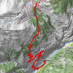
Featuring a varied descent spanning roughly 1,200 altitude metres, the tour from Giw to Visp is a real enduro highlight of the Valais Alps.
- Teškoća
-
srednje
- Vrednovanje
-
- Wegverlauf
-
Giw0,0 kmBergrestaurant Giw0,0 kmBodme3,0 kmAra5,4 kmHotee (1.210 m)6,8 kmEvangelisch-reformierte Kirche11,4 kmVisp (658 m)11,9 kmViège (651 m)12,1 km
- Beste Jahreszeit
-
sijveljožutrasvilipsrpkolrujlisstupro
- Höchster Punkt
- 1.959 m
- Zielpunkt
-
Visp
- Höhenprofil
-
 © outdooractive.com


- Autor
-
Die Tour Giw Enduro wird von outdooractive.com bereitgestellt.
GPS Downloads


Putevi
Pokus
Opće informacije
Einkehrmöglichkeit
Kulturell/Historisch
Geheimtipp
Flora
Fauna
Aussichtsreich
Weitere Touren in den Regionen
-
Oberwallis
211
-
Rund um Visp
94
-
Visperterminen
21