© Valais/Wallis Promotion - David Carlier

- Kratak opis
-
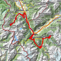
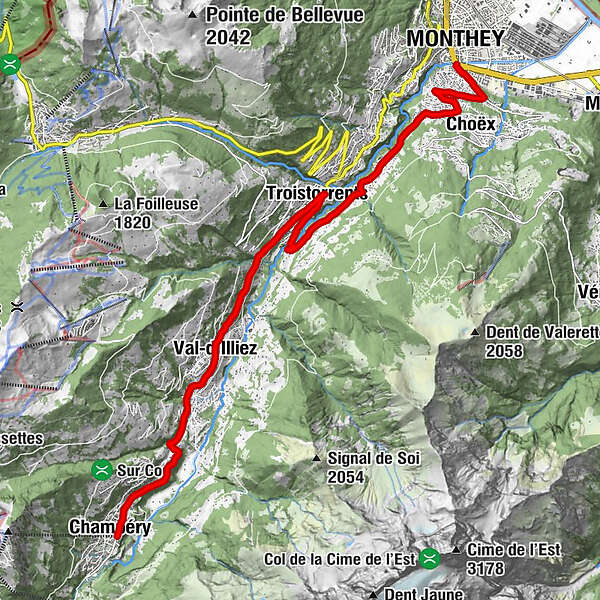
On a magnificent alpine pass route, you leave the Rhone valley behind and take the left bank of the Val d'Illiez as far as Troistorrents. Then, the climb heads in the direction of the villages of Val d'Illiez and Champéry.
- Teškoća
-
srednje
- Vrednovanje
-
- Wegverlauf
-
Monthey (430 m)Choëx2,2 kmAuberge de la Bourgeoisie7,8 kmTroistorrents7,9 kmTroistorrents (770 m)8,0 kmHotel du Repos11,2 kméglise St-Maurice et clocher11,2 kmVal-d'Illiez11,3 kmChampéry (1.050 m)15,4 km
- Beste Jahreszeit
-
sijveljožutrasvilipsrpkolrujlisstupro
- Höchster Punkt
- 1.045 m
- Zielpunkt
-
Champéry
- Höhenprofil
-
 © outdooractive.com
- Autor
-
Die Tour Val d’Illiez - Scenic & side valleys wird von outdooractive.com bereitgestellt.
GPS Downloads


Opće informacije
Einkehrmöglichkeit
Kulturell/Historisch
Flora
Fauna
Aussichtsreich
Weitere Touren in den Regionen