


Challenging mountain route for experienced and fit mountaineers
Attention: Please inquire about the current trail and weather conditions before every route!
From the starting point (Alpengasthof Wolayersee)...
Challenging mountain route for experienced and fit mountaineers
Attention: Please inquire about the current trail and weather conditions before every route!
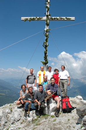
From the starting point (Alpengasthof Wolayersee) in Wodmaier, you hike to a fork in the path. You continue on the left path and will soon see the sign "to Plenge" on a nearby tree. From here, the marking to Plenge is indicated in red. You must be an experienced and mountain-savvy hiker who is not afraid of heights. Good footwear and warm clothing are required. Bringing children under 14 years is not recommended. Wodmaier approx. 5 hrs. No drinking water is available on this hike. The ascent is only recommended in good and dry weather. Please do not leave the marked trail under any circumstances during this route. The control stamp is located at the summit cross.
Walking time there and back: 10 h

Attention: Please inquire about the current trail and weather conditions before every route!
From the starting point (Alpengasthof Wolayersee) in Wodmaier, you hike to a fork in the path. You continue on the left path and will soon see the sign "to Plenge" on a nearby tree. From here, the marking to Plenge is indicated in red. You must be an experienced and mountain-savvy hiker who is not afraid of heights. Good footwear and warm clothing are required. Bringing children under 14 years is not recommended. Wodmaier approx. 5 hrs. No drinking water is available on this hike. The ascent is only recommended in good and dry weather. Please do not leave the marked trail under any circumstances during this route. The control stamp is located at the summit cross.
Walking time there and back: 10 h
Yes
Requirements: good footwear, rainwear, carry drinking water. Absolute surefootedness and no fear of heights are necessary to climb Plenge. Difficulty level 1+, only recommended for well-trained mountaineers.
Absolute surefootedness, mountain experience, no fear of heights required.
Inform yourself about the current weather situation!
Inquire about the current trail situation or any possible trail closures before the route.
Either via Sillian (Tassenbach) or Kötschach-Mauthen to the Lesachtal up to Podlanig. From there, the road branches off towards Wodmaier.
in Wodmaier
If needed, hire a mountain guide
Refreshment possibility in Wodmaier - Alpenhof Wolayersee.
Popular tours in the neighbourhood
-
4,8
Lienzer Dolomiten-Lasertörl
mediumPješačenje 13,2 km -
3,9
Karlsbader Hütte - Lienzer Dolomiten
Pješačenje 8 km -
4,3
Mountainbiketour von der Hubertuskapelle zum Wolayersee
heavyMountainbike 9,06 km -
4,9
Karnischer Hauptkamm - Hohe Warte 2.780m - Hike and Bike
heavyPješačenje 19,5 km -
3,7
Cellon-Stollen und Senza Confini auf den Cellon und Steinberger Weg zum Abstieg
mediumVia ferrata 7,09 km -
4,5
Karnischer Höhenweg – Etappe 4: Hochweißsteinhaus – Wolayersee Hütte
heavyDaljinska planinarska staza 15,9 km -
2,9
Wolayersee
heavyPješačenje 7,90 km -
3,6
RW_N61 Kleiner Pal (1,867 m)
mediumPješačenje 6,95 km -
3,9
Summit hike to the Hochstadel
mediumPješačenje 7,83 km -
2,6
Lienzer Dolomiten: Karlsbader Hütte und Laserzwand
lightPješačenje 5,91 km
bergfex Tours


Ne propustite ponude i inspiraciju za vaš sljedeći odmor
Your e-mail address has been added to the mailing list.